The Prefecture of Kavala is located between the prefectures of Serres, Drama and Xanthi and it also includes the island of Thassos. It is a mountainous region with Paggeo Mountain to the west, the mountains of the basin to the northeast and Mount Simbolo to the Southwest. There are only a few plains in Kavala and they are all located between these mountains. Nestos River is the most important river in the region as it irrigates the plain of Chrysoupolis. The coast of the prefecture has very few natural harbors with the most important one being the port of Kavala.
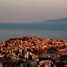
The city of Kavala is the administrative, cultural and commercial center of the region. It is located at the foot of Mount Simbolo and it is the second largest city in Macedonia. The local economy is mainly based on trade and the provision of services while there is also a considerable industrial activity in the region. Also the fishing industry plays an important role in the economy as the city has one of the largest fish markets in the Mediterranean. The city of Kavala is one of the most beautiful Greek cities with a beautiful coastline and a big number of listed buildings and Byzantine and Ottoman monuments.
Just an hour by boat from the port of Kavala, there is the beautiful island of Thassos, an island covered by dense forests of firs, oaks and pines. There are also olive groves that thrive all along the coast and many beautiful beaches. Some of them are organized while others are more secluded, but a common characteristic for both alternatives, is the clean turquoise waters. The island has seen intense touristic development with the construction of numerous facilities, especially in coastal areas. In the mountains of the island there are several picturesque villages that retain their traditional character as Panagia, Theologos and Kazaviti.